| label2 = Utilizing Layer | data2 = [[{{PARENTPAGES}}|{{PAGENAME:{{PARENTPAGES}}}}]]
431 bytes (48 words) - 15:05, 16 June 2021
| header1 = Layer Info
Here you can add information about how the layer is implemented or used in the MSP Challenge
1 KB (184 words) - 11:40, 6 October 2021
| label2 = Utilizing Layer | data2 = [[{{PARENTPAGES}}|{{PAGENAME:{{PARENTPAGES}}}}]]
427 bytes (48 words) - 15:37, 10 June 2021
| label2 = Utilizing Layer | data2 = [[{{PARENTPAGES}}|{{PAGENAME:{{PARENTPAGES}}}}]]
433 bytes (48 words) - 11:37, 6 October 2021
| label2 = Utilizing Layer | data2 = [[{{PARENTPAGES}}|{{PAGENAME:{{PARENTPAGES}}}}]]
434 bytes (50 words) - 15:34, 10 June 2021
| header1 = Layer Info
Electricity Cables is a static data layer. They are point-by-point lines that you can draw in, edit or remove when ma
2 KB (221 words) - 20:09, 17 November 2020
| label2 = Utilizing Layer | data2 = [[{{PARENTPAGES}}|{{PAGENAME:{{PARENTPAGES}}}}]]
442 bytes (49 words) - 15:06, 16 June 2021
| label2 = Utilizing Layer | data2 = [[{{PARENTPAGES}}|{{PAGENAME:{{PARENTPAGES}}}}]]
425 bytes (48 words) - 11:40, 6 October 2021
| label2 = Utilizing Layer | data2 = [[{{PARENTPAGES}}|{{PAGENAME:{{PARENTPAGES}}}}]]
438 bytes (50 words) - 15:38, 10 June 2021
| label2 = Utilizing Layer | data2 = [[{{PARENTPAGES}}|{{PAGENAME:{{PARENTPAGES}}}}]]
438 bytes (49 words) - 11:38, 6 October 2021
| header1 = Layer Info
This layer is just a background layer.
2 KB (293 words) - 14:53, 26 August 2021
| header1 = Layer Info
| header10 = Layer
849 bytes (107 words) - 20:38, 17 November 2020
| header1 = Layer Info
Here you can add information about how the layer is implemented or used in the MSP Challenge
2 KB (199 words) - 15:06, 16 June 2021
| header1 = Layer Info
Wave Height is a static data layer, providing useful information for planning different human activities, e.g.
3 KB (386 words) - 12:38, 16 May 2024
| label2 = Utilizing Layer | data2 = [[{{PARENTPAGES}}|{{PAGENAME:{{PARENTPAGES}}}}]]
435 bytes (49 words) - 15:38, 10 June 2021
| label2 = Utilizing Layer | data2 = [[{{PARENTPAGES}}|{{PAGENAME:{{PARENTPAGES}}}}]]
439 bytes (49 words) - 11:38, 6 October 2021
| label2 = Utilizing Layer | data2 = [[{{PARENTPAGES}}|{{PAGENAME:{{PARENTPAGES}}}}]]
459 bytes (52 words) - 15:35, 10 June 2021
| header1 = Layer Info
Artificial substrate is a month-by-month computer generated data layer, based on any of the following human activities:
1 KB (178 words) - 09:40, 1 April 2021
| label2 = Utilizing Layer | data2 = [[{{PARENTPAGES}}|{{PAGENAME:{{PARENTPAGES}}}}]]
428 bytes (50 words) - 15:07, 16 June 2021
| header1 = Layer Info
...t to Lambert Azimuthal Equal Area (EPSG:3035). Extracted features from the layer that covered the sea area and simplified extracted features.
3 KB (447 words) - 12:35, 19 December 2023
| label2 = Utilizing Layer | data2 = [[{{PARENTPAGES}}|{{PAGENAME:{{PARENTPAGES}}}}]]
427 bytes (48 words) - 15:04, 16 June 2021
| label2 = Utilizing Layer | data2 = [[{{PARENTPAGES}}|{{PAGENAME:{{PARENTPAGES}}}}]]
434 bytes (49 words) - 11:39, 6 October 2021
| label2 = Utilizing Layer | data2 = [[{{PARENTPAGES}}|{{PAGENAME:{{PARENTPAGES}}}}]]
425 bytes (48 words) - 15:35, 10 June 2021
| label2 = Utilizing Layer | data2 = [[{{PARENTPAGES}}|{{PAGENAME:{{PARENTPAGES}}}}]]
427 bytes (48 words) - 15:07, 16 June 2021
| header1 = Layer Info
This layer is only present in the '''Digitwin North Sea Edition'''.
5 KB (709 words) - 14:35, 3 April 2023
| header1 = Layer Info
Passenger Intensity is a month-by-month, computer generated data layer showing a 'heat map' of main passenger cruise line traffic. The shipping si
2 KB (325 words) - 09:41, 1 April 2021
| header1 = Layer Info
Here you can add information about how the layer is implemented or used in the MSP Challenge
1 KB (178 words) - 15:04, 16 June 2021
| label2 = Utilizing Layer | data2 = [[{{PARENTPAGES}}|{{PAGENAME:{{PARENTPAGES}}}}]]
424 bytes (48 words) - 11:39, 6 October 2021
| label2 = Utilizing Layer | data2 = [[{{PARENTPAGES}}|{{PAGENAME:{{PARENTPAGES}}}}]]
434 bytes (49 words) - 15:36, 10 June 2021
| label2 = Utilizing Layer | data2 = [[{{PARENTPAGES}}|{{PAGENAME:{{PARENTPAGES}}}}]]
445 bytes (51 words) - 15:36, 10 June 2021
| label2 = Utilizing Layer | data2 = [[{{PARENTPAGES}}|{{PAGENAME:{{PARENTPAGES}}}}]]
424 bytes (48 words) - 11:36, 6 October 2021
| header1 = Layer Info
The General Boating Areas layer shows popular areas for boating in general.
2 KB (209 words) - 07:06, 4 April 2023
| header1 = Layer Info
2 KB (312 words) - 14:29, 6 April 2021
| title = NAME OF THE LAYER/TYPE
| header1 = Layer Info
859 bytes (117 words) - 13:23, 17 November 2020
| label2 = Utilizing Layer | data2 = [[{{PARENTPAGES}}|{{PAGENAME:{{PARENTPAGES}}}}]]
445 bytes (50 words) - 15:05, 16 June 2021
| label2 = Utilizing Layer | data2 = [[{{PARENTPAGES}}|{{PAGENAME:{{PARENTPAGES}}}}]]
428 bytes (48 words) - 11:39, 6 October 2021
| header1 = Layer Info
Here you can add information about how the layer is implemented or used in the MSP Challenge
783 bytes (93 words) - 15:36, 10 June 2021
| label2 = Utilizing Layer | data2 = [[{{PARENTPAGES}}|{{PAGENAME:{{PARENTPAGES}}}}]]
428 bytes (48 words) - 11:37, 6 October 2021
| header1 = Layer Info
...cts areas where [[Seine Catch|Seine fleets]] are not allowed to fish. This layer is calculated by the simulations in the MSP Challenge.
2 KB (261 words) - 13:35, 4 April 2023
| header1 = Layer Info
| header10 = Layer
798 bytes (92 words) - 14:29, 6 April 2021
| header1 = Layer Info
Eutrophication Status is a static data layer.
1 KB (184 words) - 20:09, 17 November 2020
| label2 = Utilizing Layer | data2 = [[{{PARENTPAGES}}|{{PAGENAME:{{PARENTPAGES}}}}]]
439 bytes (49 words) - 15:05, 16 June 2021
| label2 = Utilizing Layer | data2 = [[{{PARENTPAGES}}|{{PAGENAME:{{PARENTPAGES}}}}]]
427 bytes (48 words) - 11:40, 6 October 2021
| label2 = Utilizing Layer | data2 = [[{{PARENTPAGES}}|{{PAGENAME:{{PARENTPAGES}}}}]]
436 bytes (49 words) - 15:37, 10 June 2021
| label2 = Utilizing Layer | data2 = [[{{PARENTPAGES}}|{{PAGENAME:{{PARENTPAGES}}}}]]
424 bytes (48 words) - 11:37, 6 October 2021
| header1 = Layer Info
4 KB (552 words) - 13:40, 6 April 2021
| header1 = Layer Info
Artificial substrate is a month-by-month computer generated data layer, based on any of the following human activities:
1 KB (182 words) - 20:08, 17 November 2020
| header1 = Layer Info
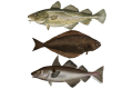
Benthic invertebrates is a month-by-month, computer generated data layer following calculations made by the ecosystem simulation (EwE).
1 KB (182 words) - 20:08, 17 November 2020
| label2 = Utilizing Layer | data2 = [[{{PARENTPAGES}}|{{PAGENAME:{{PARENTPAGES}}}}]]
448 bytes (51 words) - 15:06, 16 June 2021
| label2 = Utilizing Layer | data2 = [[{{PARENTPAGES}}|{{PAGENAME:{{PARENTPAGES}}}}]]
425 bytes (48 words) - 11:40, 6 October 2021


 Co-funded by the European Union.